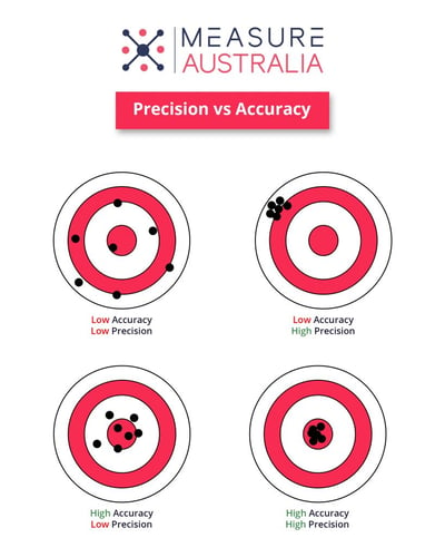
A topic of frequent discussion in the survey industry is the relationship between precision and accuracy regarding LiDAR laser survey technology. Often, these discussions prove problematic because there is some differentiation in the way people view precision and accuracy. Here, we will compare and contrast both in terms of LiDAR laser survey and discuss them concerning survey deliverables and the quality of output data.
Defining Precision
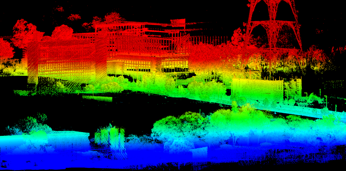
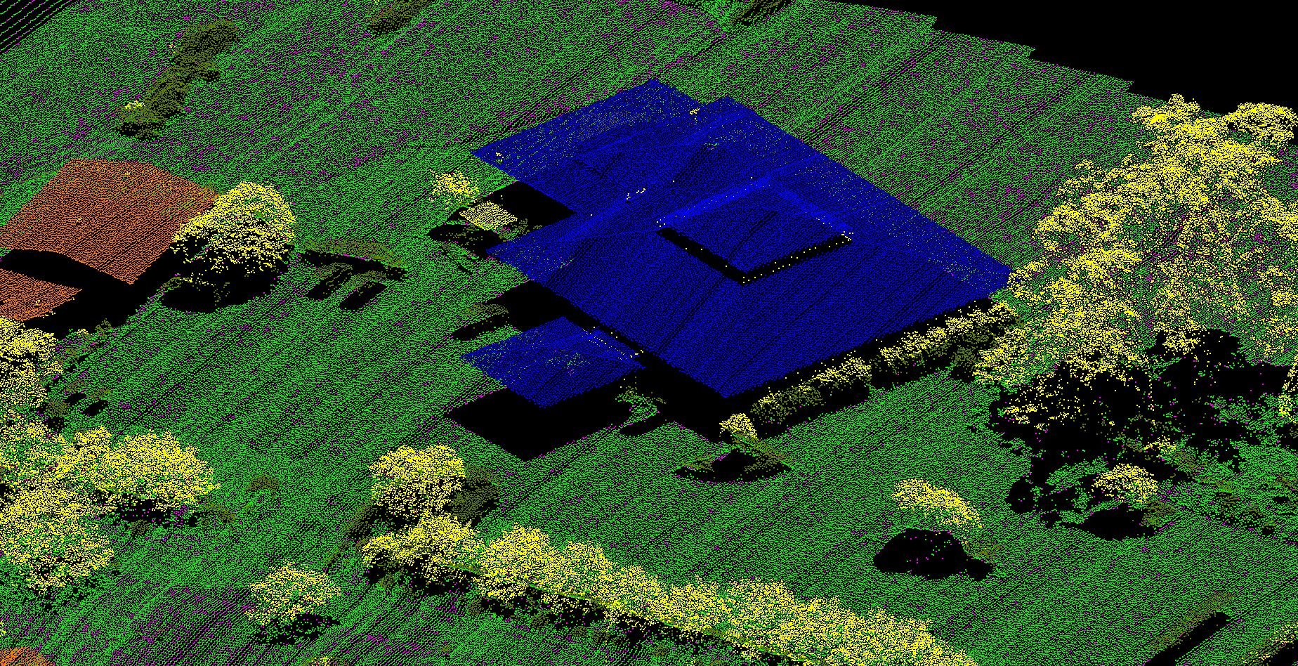
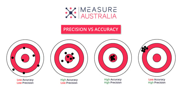
In reference to LiDAR laser survey, precision can best be described as a measure of repeatability. Under identical circumstances, you would produce a repeated measurement with precise collection methods. This repeatability underscores the precision of your measuring system. So, in LiDAR laser survey systems for UAV, for example, you might consider precision to be how clean/crisp your point-cloud looks. In lower precision systems, point clouds appear to have a lot of noise (or fuzziness). In a precise system, you can expect to see a well-defined point cloud and little noise.
Defining Accuracy
Simply stated, accuracy is best defined as how close a measurement is to the real value. You must keep in mind that you cannot make any assessments about accuracy unless you have a standard by which to base your comparisons. When it comes to geospatial work, there are two types of accuracy to keep in mind. Network accuracy is associated with how closely the measurements match the known datum. The other type of accuracy is termed local accuracy or relative accuracy; local accuracy has to do with the accuracy of measurement concerning a standard.
Relative Accuracy vs Absolute Accuracy
We have to make a distinction between absolute and relative accuracy. Which measure you choose to use depends on your application. When you are involved in a survey, you are always going to be able to find the relative accuracy. However, if your survey data requires analysis in reference to other data sets, you will need to rely on absolute accuracy. As an example, consider: define a point in a three-dimensional model to its position in the real world. For this type of analysis, you would need high absolute accuracy in order to take the coordinate system in use into your consideration.
Accuracy and LiDAR Laser Survey Systems
A fully integrated LiDAR laser survey system has different components and will have a defined accuracy value. The LiDAR sensor/laser head will have a range of error, and the accuracy value will be expressed either as an angle or a distance. To determine the accuracy of their LiDAR laser survey system operators are tasked to rely on formulas that take into account the accuracies of the different components. And, of course, the higher the accuracy, the better the results.
The Importance of Precision and Accuracy in Survey Deliverables
Measurements are essential for quality management. If you have a survey that is both precise and accurate, you have a deliverable that is effectively free from flaws. While all LiDAR laser surveys will have some error remaining, no matter the precision and accuracy of the datasets, a higher quality system and skilled processing team will reduce the errors associated with each. It is in the purview of the project management team or operators to determine the level of precision and accuracy that their deliverables must achieve. With precision and accuracy in place, decision-makers can rely on their data to make important (and often expensive) decisions.
Advantages of LiDAR Laser Survey over Traditional Surveying Methods
Assuming both precision and accuracy in LiDAR laser surveying and traditional land surveying are high, LiDAR laser survey exhibits several advantages over traditional surveying methods. First, there is the issue of speed. LiDAR laser survey systems can collect upwards of one million points of data in a single second, so LiDAR laser surveying is incredibly fast. To put that into perspective, a LiDAR laser survey building scan may take roughly two to three minutes. A large scan might still take only an hour to complete. Traditional surveying methods cannot beat LiDAR laser surveying for speed and coverage.
Another benefit of LiDAR laser surveying is its flexibility. When it comes to surveying, there are multiple options to select from that achieve a range of results. Depending on the needs of an application, LiDAR laser surveying systems may be set up on a wide range of platforms. In some cases, a stationary tripod suffices (terrestrial) while a vehicle (mobile) or aircraft/drones (aerial) may be used. For large area surveying, collection using manned or unmanned aircraft is the only feasible option. This flexibility even extends to the time of the surveying project as LiDAR laser surveying can be collected day or night in a range of weather conditions.
Another benefit of LiDAR laser survey systems mounted on drones is that they can be operated safely at a distance. So, if there is a need to survey a tract of land or area that is dangerous, using unmanned LiDAR laser survey methods is a good choice. LiDAR laser survey systems mounted to drones can be sent into areas that would otherwise be unsafe for humans to enter. That is a significant advantage of LiDAR laser surveying methods when compared to traditional survey techniques.
Can Precision and Accuracy Be Increased in LiDAR Laser Survey Systems?
In short, yes; it is possible to improve accuracy and precision, and that underscores how LiDAR laser survey systems can have drawbacks when high-quality components are not used, or a skilled team does not undertake the collection and processing. First, to improve a LiDAR laser survey system, improve its individual components. Some systems may not employ the highest-quality components, and that will necessarily impact their precision and accuracy. By ensuring that the components are high-quality, certified and independently verified, operators can increase the precision and accuracy of their LiDAR laser survey system.
Also, when the LiDAR laser survey system is operated by certified professionals, there will be more reliable and accurate geospatial information. When these systems are not operated with a high level of expertise, there is an opportunity for reduced precision and accuracy. In short, to improve the LiDAR laser survey’s precision and accuracy, ensure only highly skilled operators are used.
When in the hands of experienced operators and designed with high-quality components, LiDAR laser survey systems collect precise and accurate information. When it comes to traditional surveying methods that are also precise and accurate, it appears that LiDAR laser survey outperforms them nevertheless when compared on many aspects including coverage, speed and level of detail.
Measure Australia has provided LiDAR drone solutions for various industries and numerous companies around Australia. View some of Measure Australia’s LiDAR data samples. Our experts with 10+ years of experience are enthusiastic about providing the right solution for every client and on every project. Get in touch with our experts or contact us today.
Follow us on LinkedIn for future updates!